
How to connect your PalmOS PDA to the Garmin eTrex to use GPS-enabled maps
![]()

One of the advantage of joining egroups such as palmx, you get exposed to esoteric stuff such as GPS. GPS stands for Global Positioning System and it consists of 24 earth-orbiting satellites. These satellites allow any person who owns a GPS receiver to determine his or her precise longitude, latitude and altitude anywhere on the planet. For as little as USD115, you can know exactly where you are and where you have been (for more details on how GPS works, please click here). Best of all, the service itself is free. There is no monthly subscription to be paid and there is no other charges to be paid besides the cost of acquiring the GPS receiver. In palmx.org, there are a few GPS receiver users such as Hamid Misnan and Captain Mohd Idrus Mohd Dari. Based on their input, I bought my Garmin eTrex early this year.
The receiver by itself is already pretty useful. Whenever I used it for cycling, I would know the route that I took, the distance travelled, my current, maximum & average speed and the time to arrive to my destination. When I used it to travel out-station, it is also pretty useful since I can see my “real” speed, the direction that I need to take and the time to arrive to my destination. I could also note the exact distance travelled, which is pretty useful when it comes to filling up your mileage claim.
But once you combine the GPS receiver with your PalmOS PDA, the usefulness increased. With the computing power of your PDA and the tracking power of your GPS receiver, you can navigate yourself using GPS-enabled maps. That is the aim of this article, to guide fellow Malaysians on how to do so. Since it involves two different equipment and two different operating system, I’ll break up the topics accordingly.
GPS Receiver
There are many types of GPS receivers in the market. There are even models customised for specific PalmOS PDA such as the Magellan® GPS Companion for Palm™ m500, Nexian HandyGPS Pro for Visors and Navman GPS for Palm m-series, III, IIIc, V & VII (check out the RandMcNally site for more info on these items).
But I opted for the stand-alone model such as the Garmin eTrex, based on the good advice of Captain Mohd Idrus. You can read up on it at http://www.lexicon.net/firstwaypoint/gps/etrex.htm. There used to be a better review on it at http://www.gadgetmad.com/reviews/etrex.shtml but the site is no longer accesible.
What model that you decide to get for yourself, doesn’t really matter here. What matters is whether you can get the necessary cables to connect the PDA and the GPS receiver together. Therefore I would recommend Garmin GPS receivers over other brands since the necessary cables are easily available from http://www.pc-mobile.net/gps.htm
1. Getting Connected:
You can make your own data cable by following the instructions at http://www.lexicon.net/firstwaypoint/gps/datacable.htm and http://www.lexicon.net/firstwaypoint/gps/etrexdatawiring.htm.

If you plan to connect it to a serial connection via a d-connector, you can follow the instruction from http://www.lexicon.net/firstwaypoint/assets/dconnector.jpg
But if you plan to connect it to your PalmOS PDA, then you have to search for the necessary schematics and connectors.
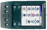
I took the easy way out by buying my own customised cable from http://www.pc-mobile.net/gps.htm. The service is quite good since I received the item within a week of ordering it (compare it with the 3 months that it took for Amazon to deliver my books to me!). Below is the picture of the cable and how it is connected to the Clie and the eTrex.

You can also check out the commercial eTrex cables at http://www.lexicon.net/firstwaypoint/gps/etrexcommercialplugs.htm
This should be able to give you a rough idea on how expensive GPS accesories could be 😛
2.Configuring the eTrex
The next step is to ensure that your GPS receiver is giving the necessary data output to your PDA. For the eTrex;
- Navigate to the Menu page and select “SETUP”.

- Select “INTERFACE”.
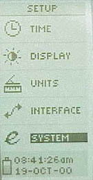
- Then for I/O Format, select “NMEA OUT”. Set the baud rate at 4800. Once done, click “OK” and exit the Menu page.
PalmOS PDA
1. Choosing the Application
There are plenty of GPS applications available for PalmOS PDA. For example, check out this link at http://www.lexicon.net/firstwaypoint/gps/links.htm. Of the many listed there, GPilotS is one software that you should have on your PDA. For your PC, it would be GARTrip. These will augment the capability of the GPS receiver.
But we are discussing navigation using GPS-enabled maps here, therefore I will concentrate on two applications;
- Mapopolis (free) – http://www.mapapolis.com/
- HandMap (requires registration) – http://www.handmap.net/
For a blow by blow comparison of mapping applications, please visit http://www.palminfocenter.com/print.asp?ID=2185
I’m only interested on which of the above two is suitable for local users, therefore I wont be doing a blow by blow comparison. If you have limited memory space on your PDA, I would like to suggest that you download only Mapopolis.
2. Acquiring the Local Maps
For Mapopolis users, they can download the maps of local cities from http://www.virtualmalaysia.com/mobile/pda.cfm. Currently there are only maps of Kuala Lumpur and Johor Baru, but apparently they hope to do for all cities in Malaysia. Let us hope that they managed to do so.
Latest update;
Just a tip for all Mapopolis users; Install the Kuantan, Penang, Ipoh & KL maps then tick the “load contigous maps” box.
You will find that you can view the roads from Penang, South of Kedah, Perak, Pahang, most of Selangor and Kuala Lumpur in one continous view! Imagine travelling in these area with this apps, it will automatically switch view without any need to load in the new map.
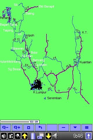
Don’t bother to include Seremban, it didn’t extend to Seremban when I tried it.
A member of mypdacafe whose handle is “The Saint”, created a PocketPC maplet of Kuala Lumpur. I managed to convert it for PalmOS users. It is available from http://www.palmx.org/image/maplet-kl.zip
For HandMap users, the only useful map that I could find for us Malaysian is the World Map at http://www.handmap.net/Palm/Evolutionary/world-map.zip. Unfortunately, it will work for registered users only. But that has never stopped palmexers before 😉

Update:28/08/02 – found a huge collection of local HandMap maps at http://www.geocities.com/maps2mlap/downloads.htm but these maps are not GPS-enabled.