
Previously the Malaysian PDA GPS Navigation community had to be contented with Mapopolis and the Malaysian cities map from Virtual Malaysia. Now we are spoiled for choice. At the last count, there were 3 such applications available for us Malaysian users and there may be more in the near future (click here for an upcoming product from MapKing). Therefore we at PalmX thought that it is about time to bring a head to head comparison between these applications.
The applications are;
- Mapopolis with maps from Virtual Malaysia (Mapopolis VM) – PalmOS & PPC
- agisNavigator(agisNav) – PalmOS (not GPS-enabled) & PPC (GPS-enabled)
- Pocket Map Viewer with maps from GPS MAP Malaysia Singapore (PocketMV GPSMAPMySg) – PPC only
In this head to head comparison, we will be comparing based upon;
- Quality of Maps
- Routing & Re-routing
- Voice Navigation
- Ease of Use
- Usability without GPS Receiver
- Points of Interest
- Navigation Aids
- GPS Acquisition Screen
- Map Display Comparison
Quality of Maps
Maps are really the most important item in any GPS software. Even more so when you’re looking for a specific street on the map and using it for routing. Road maps have to be spot on with every highway, road, lane and roundabout shown, otherwise users will complain. However it is impossible to have maps that are 100% accurate with the development of new roads, highways, roundabouts and road layouts that have changed. The best you can probably expect would be nearer the 80% mark of accuracy. But even the best mapping companies in Malaysia such as RIMMAN may not have maps with such accuracy. Therefore what can we expect from the lesser companies/groups that produce maps for the above applications?
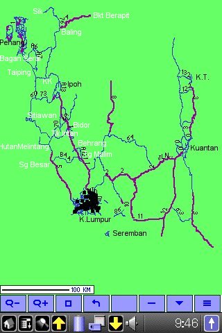
For Mapopolis VM, the maps are the free maps from Virtual Malaysia. They only cover the following cities;
The qualities vary from good (KL & KT), usable (Penang, Ipoh, Malacca, Seremban & Kuantan) to poor (Johor Bahru). I’ve personally tried out all of them except for Kuala Terengganu, while driving in the respective cities. Please refer to this article, for the screen shots of the maps of all the cities. Since Virtual Malaysia is producing these maps for free, we can’t expect the company to continuously update it. There is no monetary incentive for them to do so. Even now, their best map, which is the KL map is already very much outdated. In fact all VM maps can’t be used on the latest Mapopolis application, instead we have to make do with Mapopolis version 3.X for PPC and version 5.19 for PalmOS.
Therefore we have to look elsewhere for better and more frequently updated maps. BTW for Johor Bahru, there is a better map produced by lennyfoo876@yahoo.com at GIS Malaysia.
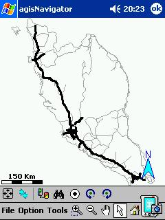
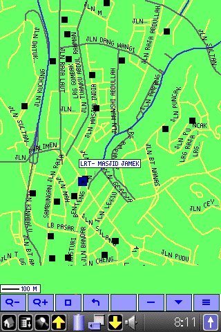
For agisNavigator, it comes with a general map of Peninsular Malaysia and its major roads. It has excellent maps of some of the cities (such as Kuala Lumpur, Ipoh, Johor Bahru, Kuala Terengganu and Penang) and the highways (except for the new East Coast Highway). For Kuala Lumpur, even the buildings and the LRT system are displayed. However maps of some of the other major cities such as Kuantan need to be improved upon. Despite being a commercial software with a premium price, there don’t seem to be any method for us to update the maps; neither at its website nor through the application itself.
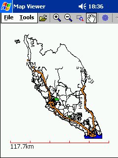 The Pocket MapViewer by Ng Wee Hong can utilise any maps in the Garmin *.img format. Therefore good maps is no longer a problem since there is a huge repository of such maps on the Internet. Check out MapCenter for an example. For the local users we have an excellent group at http://groups.msn.com/GPSMapMalaysiaSingapore, co-ordinated by Aprivate and adil-my-2003 , whose group has been doing an excellent job of regularly updating and improving their map which is available in the Garmin *.img format.
It is a joy to use their map. The map is very accurate and quite comprehensive. The map is prepared with the drivers in mind, therefore it is very easy to comprehend and sometimes enlightening to use. Although not all the minor roads are included but most, if not all the major highways, trunk roads and important routes are there in the map. Even my favourite route of going back to my in-laws place in Sabak Bernam (via Behrang, Felda Gedangsa, Lubok Pusing and Sepintas) is there in the map! I only discovered the route in 1996 when I had to visit my students doing research in Gedangsa. Even then I had to pore through the huge JUPEM paper map to ensure that I took the right route there since there were so many junctions especially after Lubok Pusing. This small example proves that it is indeed an excellent map to have around.
The update rate is also fantastic. For example the SILK highway is included within a week after being officially opened. The new East-West Highway was included within 2 weeks after the launch.
In summary, in terms of map quality, the map from GPSMapSgMly comes out tops, followed by agisNavigator and VM Mapopolis maps.
Routing & Re-routing
When you’re looking to get from A to B, routing will help you to identify the route while re-routing will help if you leave the chosen route. Re-Routing is something that’s fairly new to PDA Navigation. When you leave the chosen route, the aim of the re-routing is to look at the destination location, and where you currently are, and depending on the various re-routing options selected it should re-route you to your destination.
Mapopolis supports routing, unfortunately the VM maps are “BASIC” maps, therefore do not support routing.
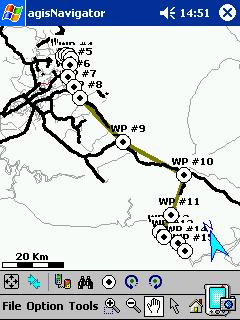
agisNavigator supposedly supports routing. But I could find no evidence of that in my review copy. Apparently only the latest version supports that and the coverage is limited to Singapore only. Instead you have to make do with “targetting” or by using waypoints to guide you to the destination. You have to painstakingly identify all the critical junctions and turns and designate the necessary waypoints. Then follow the gray line towards your destination. A workable solution but nothing to shout about.
The current PocketMV and the map from GPSMapSgMly do not support routing. But based on current discussion at their forum, members are currently hard at work trying to make their map support routing. Currently they already have the Kuala Lumpur map to support routing and it will work if the Garmin GPS receiver used with it supports routing. But since Pocket Map Viewer does not support routing yet, PDA users cannot take advantage of it.
In summary, for routing capability, agisNavigator is the best of the three products.
Voice Navigation
Routing by voice is another fairly new addition to the feature list of PDA navigation which has been known to be found on some of the more expensive in-car navigation systems. In most cases Voice directions will be recorded in maybe a dozen or two sound files, which can then be joined together to make a sentence. The software knows which turn you need to take, and can then correlate the relevant voice words to make up the sentence. This then allows most of the GPS software companies to create audio files from a human rather than a synthesised voice, and sounds more natural.
Sad to say that all of the three software discussed here, failed this test.
Although the latest version of Mapopolis supports voice navigation, our VM maps are incompatible with the latest version of Mapopolis. The VM “BASIC” maps also do not support routing. Therefore there is nothing to discuss.Strike One.
agisNavigator claims that it has voice navigation in its documentation but I could find no evidence of it. I even connected the audio output of the PDA to my car stereo system. There was only “The Sound of Silence”,….. plus a bit of static. Anyway since their map do not support routing, it doesn’t make sense to have voice navigation. Strike 2.
The same logic applies to Pocket MapViewer. Pocket MapViewer do not support voice navigation. Strike 3.
In summary, all three struck out.
Ease of Use
One of the main features of any GPS software on a PDA has to be ease of use. You don’t want to find yourself driving along, having to make a slight alteration and find you can’t get an option to set. You need nice large buttons you can press with a finger or a thumb, rather than having to be precise with the stylus.
Mapopolis passes this test easily. There are 8 large buttons at the bottom which I could easily press with my fingernail. With these buttons, I could zoom in and out, rotate the map, increase or decrease features, search or change the options. Under the options screen, there are huge buttons that allow me to change the maps, find the place/street, set the GPS or any other settings. Usually if you have prepared well before starting your journey, the main 8 large buttons are more than adequate. The best is the font which I could adjust so that I can see the name of the roads clearly while driving.
Wish I could the say the same for agisNavigator. Unfortunately I can’t. agisNav do not display the name of the roads/places automatically. Instead I have to click on it precisely to display its name. Something not that easy to do in a moving vehicle. However most of the other functions could be accessed easily from the large buttons at the bottom. However I am not too happy that in order to do things such as “Centre the map on GPS”, I had to navigate through the menus; click on “Options” and select “Center of GPS”. PocketMV have the right idea with frequently used commands being displayed as buttons. With agisNav, you better prepare everything before starting your journey, even the waypoints to your destination. Else it will be a major headache trying to figure out on what road are you driving now and where/when is the next turn.
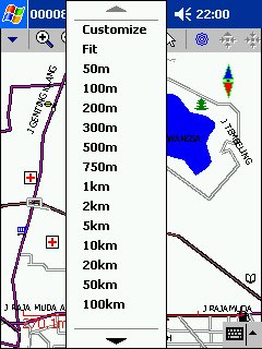
The latest version of Pocket MapViewer v.0.2.0 is much more easier to use than its predecessor. The map can be configured to load automatically upon startup. The best new addition is the “Zoom selection menu for instant zooming” which allows you to zoom in at a few preset levels. Now it is easier to reach the required zooming level. I find the scale of 5km per cm useful while I am on the highway since I can see up to 25 km ahead. In Kuala Lumpur, 300m per cm is the best scale since all the POIs and features are automatically displayed at this level. It is easy to use since I can just ask my son to tap and change the setting accordingly. No longer do I have to tell him “tap zoom in 10 times” or “tap zoom out 5 times”. Now I just tell him to zoom in 2km or 5km, according to my needs. Now it also supports “Track Up” just like the other two software. However whenever I need to orientate myself, I’ll switch to “Track North”. With “North” at the top, you can easily orientate yourself to your position. All these features (Zoom In, Zoom Out, Track North, Track Up etc) can easily be accessed through large buttons at the top of the screen. The author mentions that to view the name of the road, you have to tap on it using the Arrow button. But if I am not mistaken, the name of the road is always displayed, unlike agisNavigator.
In summary, the best is PocketMV, followed by Mapopolis VM and agisNavigator.
Usability without GPS Receiver
One thing you need to be able to do is to use the software as is and not always when you have a GPS signal. Sometimes you need to plot a route and this is when you need to use the map manually, zoom into a city, then into the local area and find the rough location and then plot a route to here.
With Mapopolis VM, you can use it without a GPS receiver. You can use the search function to find the street/place that you’re interested in and familiarise yourself with the route. However you can’t plot the route on the application itself since it has only “Basic” maps of Malaysian cities.
agisNavigator can also be used without a GPS receiver. You can search by name for the street or the building and set it as a target for you to go to. A red line will show you your destination from your current position.
Or you can identify all the critical junctions and create the necessary waypoints towards your destination. However this is a bit hard since the road names are not displayed by default. Best if you use a paper map to plot the route and transfer it onto the application.
Pocket MV is also usable without a GPS. It also allow search to be done for the street name or POI.

Since all three applications are usable without GPS, there are no clear winners here.
Points of Interest
As mapping software gets better, so does Points of Interest (POI). Anything from Car Parks to Hotels, from Restaurants to Coffee Houses. An ideal POI database would include not only the name of the Point of Interest, but also the full address and telephone number.
Such a database is possible with Mapopolis. The users can create and share such databases with others using maplets. In fact palmdoc has already started such a venture. To participate, please visit this link.
In short, such a database can easily be created for Mapopolis VM. Kudos to palmdoc for initiating this.
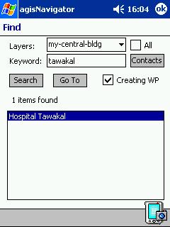
agisNavigator however do not support creation of such databases. However it does provide a database of building names for Kuala Lumpur which is searchable.
As for Pocket MV, the maps provided by GPSMapSgMy do have its own POI which is rather comprehensive, contributed by its forum members. However it is not easily editable by the casual users.

It is very hard to decide which is the best here since all of their approaches differ. Personally I prefer Mapopolis and its maplet approach.
Navigation Aids
A comparison review wouldn’t be the same if we didn’t include some screenshots to compare the three products.

Mapopolis allows you to display GPS data on the map. It displays the speed, heading and bearing but display is rather small and keeps flickering, therefore I do not find it useful.
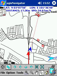
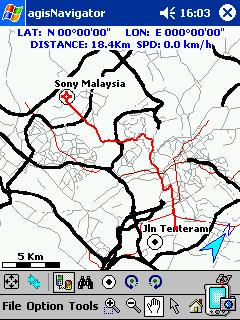
agisNavigator displays the distance travelled and speed. It could be useful but due to the constant need to reset the PPC due to its instability, I ended up relying on the GPS itself to keep track of the distance travelled.
Pocket MV do not display any of the above. Only the compass showing the direction. For measurement of distance, you have to ‘guesstimate’ using the displayed scale.
The clear winner here is agisNavigator.
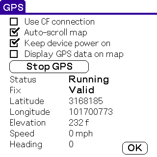
GPS Acquisition Screen
One thing you may not see much of in your journey, but you do when you commence your journey is the GPS Status screens. These for most are the essentials, you really do need to make sure you have a full 3D acquisition before commencing your journey, otherwise the acquisition time will be severely extended.
It includes all of the information you need like longitude and latitude, speed, compass direction, GPS satellite signal strength, satellite lock and an approximation where each satellite is in the sky. You will also see full UTC time as retrieved from the satellites atomic clock and a 2D/3D lock designation. The status screen should be as simple as it could be, but giving you the information you need.
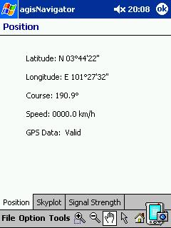
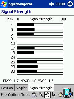

The first two images shows the GPS acquisition screen for agisNavigator. It displays the latitude, longitude, course, speed, satellites in view and the signal strength of each satellites.
The third image is of Pocket MV. The screen shows longitude, latitude, speed, direction, altitude, date, time, satellites in view and the respective signal strength. Pocket MV packaged everything nicely in a single screen.
Winner, Pocket MV.
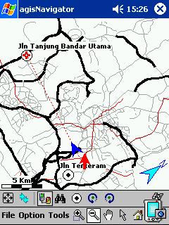
Map Display Comparison
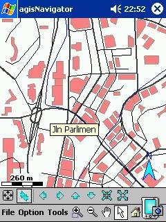
A comparison review wouldn’t be the same if we didn’t include some screenshots to compare the three products maps side by side.
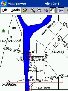
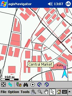
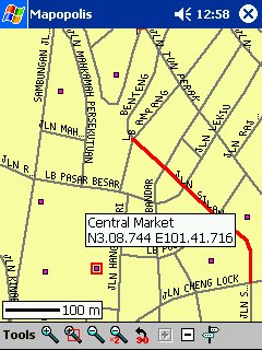
All three utilised different approaches, all in 2D not 3D. My vote still goes to Pocket MV due to rapid improvements to its map display. The above map doesn’t do it justice. Check out its website for the latest screenshots.

Overall Comparison
Currently the best PDA navigation software available in Malaysia is Pocket MV. The author keeps improving it at a rapid pace. During the time it took me to finish this article, he did two major upgrades. In fact Pocket MV is the only single reason for me to use a Pocket PC. Go ahead, check it out. Ehem..Wee Hong, any news on the Palm Map Viewer? 😉