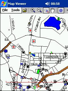
Map Viewer with map of Malaysia & Singapore
GPS-enabled Navigational Software for PPC, capable of reading Garmin maps (*.img)
Price: Shareware. Price TBA.
Review item courtesy of the author; Ng Wee Hong
(weehong@yahoo.com )
Product reviewed on ViewSonic VSMW25410 with Pocket PC 2002
I have been keeping a close eye on the development of GPS-Navigation in Malaysia for the past few years. You can see that in my previous articles published here in PalmX;
- Palm Connectivity Part 3 – GPS & GPS-enabled maps
- agisNavigator1.1: First Impression
- agisNavigator 1.1: Part 2 – GPS Navigation
As discussed in those articles, one of the big problem of GPS-Navigation in Malaysia is to have good, reliable and regularly updated GPS-enabled maps of Malaysia. Therefore it would be good if we could make use of the Garmin maps prepared by GPS Map Malaysia & Singapore under the coordination of Aprivate and adil-my-2003.
This group has been around since 23rd July 2003 and has been updating the Malaysian Singapore Garmin maps on a regular basis. The latest version is mal42g and can be downloaded from the DOCUMENTS section of the forum. However only those having navigation-capable GPS receivers such as the GPS V®/eTrex Legend® C/eTrex Vista® C/GPSMAP® 60C/GPSMAP® 76C and GPSMAP 76CS can upload the necessary local maps from the group into their GPS receivers. For the rest of us navigation enthusiasts, who wants to utilise our PDAs for navigation purposes, we either convert these maps into a format which our PDA supports (i.e. OziExplorer for PPC using MapEdit) or pray for someone to come up with an application that can read Garmin *.img maps directly.
Apparently our prayers have been answered!!!!!!!
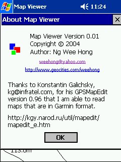
The answer to our prayers came in the form of Map Viewer, an application for PPC written by . The application was written using pure Win32 API and integrated GPS-capability through the COM port via NEMA protocol . He is still developing it. Once done, it will be offered as a shareware. The rate has yet to be determined.
He came up with 2 versions of the software. The first version (MapViewerARMSlow.exe) will display a much more detailed map but due to the extensive rendering required, it will “crawl” on an under-powered PPC. The other version (MapViewerARM.exe) will only display more information once you start zooming it, therefore it is faster.
Installation
Installation is quite easy. Just use Microsoft ActiveSync to transfer it into your PDA. Remember to transfer in the maps too. To get the latest local map of Malaysia & Singapore, go to DOCUMENTS section of the forum, look for the latest map files and download it (i.e. MAL42G, part 1 and part 2) into the same folder on your PC. Execute the part 1 and both files with be combined to create the latest 00008888.img file. Please look for the img file under C:\malsource\mal42. You can either copy it into the Documents folder on your SD card or use ActiveSync to transfer it into your PDA.
| Run the application as you usually would with any PPC application. Displayed here is the about page of the application.
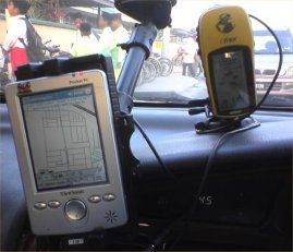
For this review, my PPC was connected to my eTrex GPS receiver, via its serial/cradle port using a customised cable. Such cables are available from PC-Mobile.
|
 |
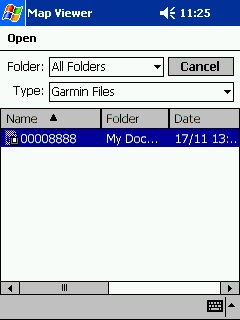 |
Upon opening up the application for the first time, there is no map displayed. You need to click on the menu “File > Open”. You will get the requester as illustrated here. Select the *.img file that you want to use and tap twice upon it. You will get the following display; |
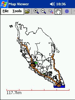 |
The entire scope of the map will be displayed upon opening it. Now you can make use of the toolbar to utilise it further. Unlike agisNavigator, you can’t “Zoom To GPS”. Therefore you have to use the “Zoom In” icon (to the left of the “hand” icon”) to select the area that you’re interested in and zoom in upon it. You may have to do this a couple of times before you’re satisfied.
Don’t use the Zoom + icon since you will have to tap up to 30 times before you get a useful display. |
 |
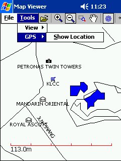
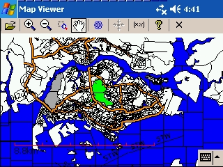
If you want to view the entire scope of the map again, click on “Tools > View > Fit”
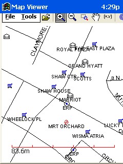
Then you will get a display similar to the above. I like the fact that it shows the names of the roads and landmarks, without any need for us to tap on it. |
GPS Navigation
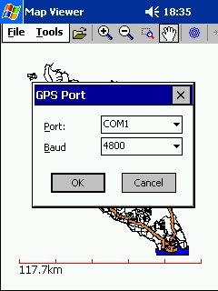 |
Once your GPS receiver is connected to the PDA, click on the icon that looks like a flower and located to the right of the “hand” icon. You will get the requester for the GPS Port as illustrated here. Make the necessary selection and click on the “OK” button.
The two items will communicate with each other and your position on the map will be displayed. |
 |
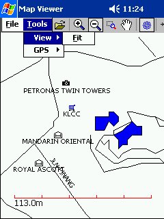
If you can’t see your position on the map, maybe your position is already off the map. To centre the map on your current location, either use the icon which is to the right of the GPS icon or click on the following menu “Tools > GPS > Show Location”. |
 |
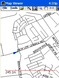
You will immediately see a blinking red icon at the centre of the display, with an arrow showing the direction of your movement. BTW I like this arrow, it is much more accurate than the arrow on agisNavigator.
The sad thing is that I can’t force the application to keep the current location always at the centre of display (auto-scroll). I keep having to press on the “Centre Location” button every now and then. It also can’t auto-rotate the map according to the direction that you’re heading (Track Up). Instead it is always North at the top (Track North). For someone who is used to the Mapopolis and agisNavigator, some readjustment is therefore required. Hopefully all these can be implemented in future development of the software. As pointed out by the author, you need some huge processing power on the PDA for this to work seamlessly. Another useful function would be to display your tracks. Therefore if you need to retrace your route, it would be invaluable. Another is Navigation via Targeting. Select a point on your map as a target and a red line line is drawn from your current position to your target. Other functions such as Search for roadname and Waypoints can be added upon later as it is not that necessary (Please refer to the green box below for the reason why). Routing is not possible on the GPS Map Malaysia & Singapore map, therefore there is no need for such function in this application for now. (Aprivate wrote on 17/8/04 : The map is NOT routable because the lines have no direction information and no crossroad information. Moreever the lines need to be perfectly joined no broken lines so that you have a network of roads. Otherwise routing calculation would stop unless you want to jump over a gap.) |
Feedback From Other Users
 |
This image was provided bythe author of the application. Please note the difference of the toolbar. This is a screengrab of the “fast” version. |
 |
This was also provided by the author, showing the GPS capability of the application, enabling the position of the person/vehicle to be displayed on the map. |
 |
For those using the latest PPC OS (Windows Mobile 2003 SE), you can even display the application in landscape mode as reported by triton tracker on 14/8/04. |
Comparison With Other Navigation Applications (to be continued)
 |
 |
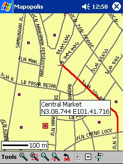 |
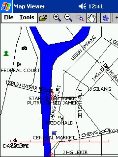
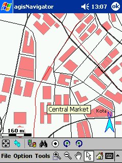
| MapViewer with Map From GPSMapMySg | agisNavigator v 1.1 | Mapopolis with map fromVirtual Malaysia |
Conclusion
I wish Ng Wee Hong all the best in his effort to come out with the Map Viewer application. I promise to support him once the product is ready. His product is the solution that many of us has been waiting for a long time. Finally PPC PDA users can utilise the excellent GPS map of Malaysia and Singapore produced by Aprivate, adil-my-2003 and company.
Now if only someone could come up with a similar product for PalmOS, then it would be fantastic! For those interested in emulating Ng Wee Hong and come up with a similar application for PalmOS platform, you can start by visiting the links below;
- http://www.palmos.com/dev/dl/dl_tools/dl_pods/index.html
- http://gpstk.sourceforge.net/doxygen/index.html
- http://kgy.narod.ru/util/mapedit/mapedit_e.htm
The Map Philosophy of the GPS Map Malaysia Singapore which was posted by adil-my-2003 sometime ago. I repost it here since the philosophy explains why their GPS Map is the BEST map around for Malaysia and Singapore.
In view of the some of the discussion here, it’s time our Map Philosophy gets some airing. Hopefully it also answers some questions that u guys might have.
- First and foremost – we would like to keep it *FREE*. Mainly we realised that even if we attempted to sell it, no one will buy!
- As far as free maps go – I would say Mapopolis is the best there is right now. Its the closest thing to a commercial map you can find which is FREE.
- This map will remain a few features short because we do not intend to upgrade to the professional compiler. In line with our *FREE* policy – if a user wanted the extra features – it would be best to buy the commercial maps. By the 1st Quarter of 2004, expect a few commercial GPS maps to be out in the Malaysian market. There is Agis Navigator which is on sale now for PDA’s. It does not work with Garmins.
- We do not intend to import Mapopolis map into the Garmin map. Apart from copyright issues – we believe that there is ample space for multiple formats to thrive and exist.
- Our map will always be *AN AMATEUR MAP*. It will never transcend itself over time to become a professional product. For example – a typical commercial map will have many additional attributes for any given road/polyline : Right Turn / Left Turn / No Right Turn / No Left Turn / U-Turn / Speed / Direction / Impedance. Not to mention each junction and intersection have to match properly. We do not have the time nor the resources to do all that. Commercial maps are the way to go if that is your interest.
- We’d consider this more of a traveller’s map. Major roads are there and so are the major towns. It’s supposed to keep you roughly on the right track wherever you are – even if you are a first timer to the area. I’m quite sure that mainroads in Perlis, Kedah are quite “out” in terms of shape and accuracy when based on the real thing – but at least you know that within that 1 or 2 km radius – there should be a road as displayed in the map. In times of distress – that may be more than enough.
- No we don’t think its necessary to plot in Jalan 22/44 in PJ or Jalan 5/1A. It clutters up the map which becomes meaningful only if u view at a zoom level of 200m or higher. Moderate details should be more than sufficient for everyone. And furthermore – since the search road function is not enabled – it is pointless to add sub-sub-sub level roads.
- Flexibility – is the biggest thing we love about the Garmin imgs. Updates and compiling are a cinch. It’s a living map which is not subjected to subscription based updates and you dont have to wait half a year for it. 🙂
- POIsed for growth. The POIs will grow and grow as we all travel and share our waypoints. Why waste your waypoint memories!? Share them and get them included in the map – this will free up more memory space for you to plot that quaint kedai kopi you tumbled across on your way to Kuantan. Overtime all your hundreds of POIs u have collected over time can be found in a single map.